There are two components to this endurance event that spans Edinburgh's Seven Hills - a competitive Race (10.15am start) and the more leisurely Challenge (9.45am start) for those who just want to complete the route.
The organisers suggest that those who can do a half-marathon in 1 hour 40 or less should probably enter The Race rather than The Challenge.
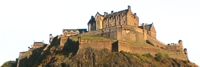
Competitors have to find their own route, as the course is not marked, but they must pass through the 6 checkpoints in the following order: The Castle (esplanade); Corstorphine Hill; Craiglockhart Hill (East); Braid Hill; Blackford Hill; and Arthur's Seat and then Calton Hill being the Start and Finish point.
Entry fee for either event is £7-£10 if you pre-register. On-the-day entries are an additional £3.
Suggested route
The organisers recommend a route for those unsure of Edinburgh's geography:
From Calton Hill. west down the steps to Waterloo Place, up North Bridge, up The Royal Mile to the Castle Esplanade checkpoint. Through the gate and steeply down the grass bank, crossing the railway by one of the footbridges, along to the west end of the Gardens, up the broad steps onto Princes Street, cross over and go down Queensferry Street for a few hundred yards, then left into Belford Road, along and up past the art galleries, then left into Ravelston Dykes and all the way along to its corner where you go straight on up the path splitting the Murrayfield golf course (do not cross the course, or we'll be in trouble), the path tending rightwards at its top and leading you around the perimeter-fence of the zoo for several hundred yards until you descend some steps and veer right into a meadow area (water-station here), and then slightly rightwards again up to the Corstorphine Hill checkpoint at Clermiston Tower.
Retrace steps to the meadow, heading down and slightly right, over to the top of Kaimes Road, descending it steeply to its foot and across the main Glasgow road to find the path opposite/slightly left which leads past the right-hand side of the very large glass office building, continuing straight southwards, along Carrick Knowe Avenue to cross the railway by the footbridge, then swing leftish along Stenhouse Drive, straight over its roundabout, to reach Gorgie Road, crossing over and moving left to soon take a right into Chesser Avenue, following it to Slateford Road where you head right under the railway bridge and then immediately left up Allan Park Road leading to a footpath over the Union Canal, at the top of which veer left up onto Colinton Road, crossing it slightly right and taking the car-entrance of the Sports Centre and straight south through between buildings to the base of the hill, where superheroes go directly up the very steep bank to the cross-path at its top, then 50 yards right before taking a left through the big hole in the wall (whilst non-superheroes took the gentle track running around the right side of the hill), and then eastwards up to the checkpoint & water-station at the top of Craiglockhart Hill East.
Head downhill eastwards (do not run across the golf course), past an (open) metal gate and veer right, taking the hard path down the southern edge of Napier College's campus to exit by a gateway onto Craiglea Place, then turn right down Morningside Grove to Greenbank Drive, which take eastwards along to its junction with Comiston Road, turning up/right and crossing over to soon ascend the steps at the base of the Braid Hills Hotel and so onto Braid Road, continuing up it to the water-station at the entrance to the east-running track, remembering to take the right fork of this after a few hundred yards, this leading up to the checkpoint (trig-point) at the top of Braid Hill.
Head leftish (NNE) across the public golf courses (beware of golfers and their balls), aiming eventually to descend by paths and gorse bushes to hit Braid Hills Drive just opposite Lang Linn Path (between metal railings), and run down the path to its corner, where superheroes go straightish on down the steep bank and cross the Braid Burn by bridge or by wet feet and ascend the opposite bank to emerge in good position for the grassy-bank ascent up past the communications towers to the checkpoint (trig-point) and water-station at the top of Blackford Hill (whilst non-superheroes took a safe right at the path's corner, going gradually down steps to cross the burn by a large wooden bridge and coming on up steps and a path veering leftwards for a few hundred yards to the foot of the grassy bank).
Turning eastwards from the hill top, run down past the Observatory and down Observatory Road and under the arch, where a left turn enables you to quickly cross and enter a gate through some allotments down onto Watertoun Road and then turning right along West Saville Terrace, at its end turning left to head up Mayfield Road until taking Duncan Street to the right, continuing over Minto Street into Blacket Avenue, then left up Dalkeith Road and cross over and turn right just after the Commonwealth Pool, into Holyrood Park Road; you soon enter the Park and then head for the water-station (a couple of hundred yards ahead half-right, then across the upper road to find some well-made steep steps leading up through a little gorge, after which it's a very steep ascent, tending slightly leftish on the way up to arrive eventually on a ridge with just a few hundred yards leftwards before climbing up the rocks to the checkpoint at the summit (trig-point) of Arthur's Seat.
Descend NE at first and then more steeply N down a bank to pick up a north-running path down The Dry Dam valley, at the end of which tend leftwards before crossing the road and heading for the east wall of Holyrood Palace where a path takes you north into the cobbled lane Croft an-Righ, at the end of which you cross Abbeyhill and Abbeymount roads quickly and take a path almost directly opposite which angles leftwards up through Regent Road Gardens, and out onto Regent Road, then moving left up that Road to pass the old Royal High School and turn sharp right into the roadway which runs up at the back of the building, up past the road elbow, then up a few steps on the left for the final 150 yards ascent over grass to the finishing-line by the Registration tent on Calton Hill